
Three routes are often collapsed into one name
Tarn Hows can describe the water itself, the main path around it, or a larger walk approaching from the surrounding woodland. These are not interchangeable. The National Trust’s main circular route begins at the Tarn Hows parking area and follows the shore. Its optional upper extension leaves that principal path. The Tom Gill approach begins lower down and adds a woodland climb. A guide that borrows the easy label from the first and the dramatic waterfall photographs from the third can create a misleading picture.
For a compact lake visit, choose the main circuit as the route objective. It has its own landscape sequence and does not need a larger approach to become a worthwhile walk. For a more demanding woodland outing, research Tom Gill separately. For somebody seeking extra elevated views after the circuit, consider the upper paths as additions with their own terrain rather than part of the basic promise.
The main loop is surfaced, but it is not completely flat
The land manager describes the main circuit as a firm gravel route with rises and descents. That combination is important. A well-defined surface reduces one kind of obstacle while leaving gradient as another consideration. Someone choosing on the basis of wheels, a pushchair or limited tolerance for slopes needs the detailed route description, not simply the adjective accessible.
The official circuit is approximately 3.2 kilometres. Use that as a definition of the published route, not as a personalised prediction of how long the visit will take. Repeated stops, approach connections and individual walking speed can change the outing substantially. The compact distance makes it possible to spend time with the landscape rather than moving constantly. It does not make every section equivalent, and a return from the water to the higher starting area is still part of the journey.
Keep the shoreline path at the extension junction
The National Trust’s directions distinguish a junction where walkers can remain on the main path around the tarn or take an uphill extension toward a higher track and viewing area. The practical decision is simple: if a consistent surfaced loop is the priority, remain with the main lakeside route. The optional extension should be chosen because its extra viewpoint and different ground suit the party, not because it appears to be the only way to finish.
This is particularly useful when following somebody else’s recorded walk. A photograph of a higher panorama may tempt you to assume the same line is suitable for the surface requirements that led you to Tarn Hows. Check the actual route branch. A shared destination name does not carry the main path’s characteristics onto adjoining tracks, fields or woodland paths. Keeping the basic loop intact is a positive route choice, not a lesser version of the visit.
A lake designed for views
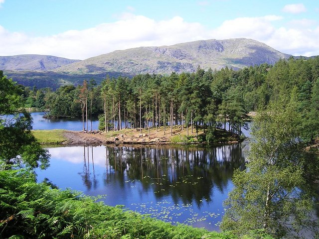
Tarn Hows is a shaped landscape rather than an untouched mountain basin. The National Trust describes nineteenth-century work that joined smaller waters and introduced planting to enhance the setting. That history changes how to look at the scene. The islands, trees and glimpses of surrounding fells can be read as a composition as well as a natural view.
A useful way to walk the circuit is to compare how the foreground changes. At one point trunks frame the water; elsewhere an opening allows the higher fells to become the main visual element. This gives a reason to complete the lake circuit without chasing a summit or adding miles. Walkers interested in photography can concentrate on legal path-side framing and reflections rather than searching for an invented hidden access point. The landscape has enough variation from its established paths.
Why Tom Gill deserves its own decision
The Tom Gill route approaches from Glen Mary Bridge and climbs through woodland near waterfalls. The National Trust identifies challenging ground and rocky scrambling on that separate outing. Those features are not explained by the main lake circuit’s distance or easy classification. An arrival at Tarn Hows by Tom Gill is therefore a different day from starting beside the main circular path.
Choose the direct loop if the intention is a short, relatively consistent shore walk. Choose a larger approach only after assessing its own surface and ascent. Avoid combining whichever description sounds easiest with whichever start happens to be convenient. That is how manageable destinations become unsuitable routes. At Tarn Hows, clarity is straightforward: define the start, stay with the main circuit if that is what you selected, and treat every extension as an additional choice requiring its own evidence.
The most useful comparison at Tarn Hows is not between clockwise and anticlockwise photographs. It is between staying beside the water on the defined main line and taking an extension that changes the surface. Decide that branch before discussing how much extra scenery the group wants.
Questions answered
Does the main circuit include the waterfall climb?
No. The Tom Gill approach is a separate route from a lower starting point. It adds more demanding woodland ground and should not inherit the main circuit’s easy description.
Can a firm path still be demanding?
Yes. Surface quality and gradient are different factors. Tarn Hows has a defined gravel route, but its rises and descents still need to match the walker or equipment using it.
Sources & scope
Route facts are drawn from the resources below. The comparisons and recommendations are our research-based editorial analysis; this is not a claim of personal trail inspection. Access and conditions must be checked with the responsible land manager before travel.
- National Trust: Tarn Hows circular walk
- National Trust: Tom Gill to Tarn Hows route
- National Trust: Tarn Hows and Coniston
Editorial standards · Explore the destination guides
Found a detail that needs correcting? Send the guide URL and a supporting source so we can review the exact route version.