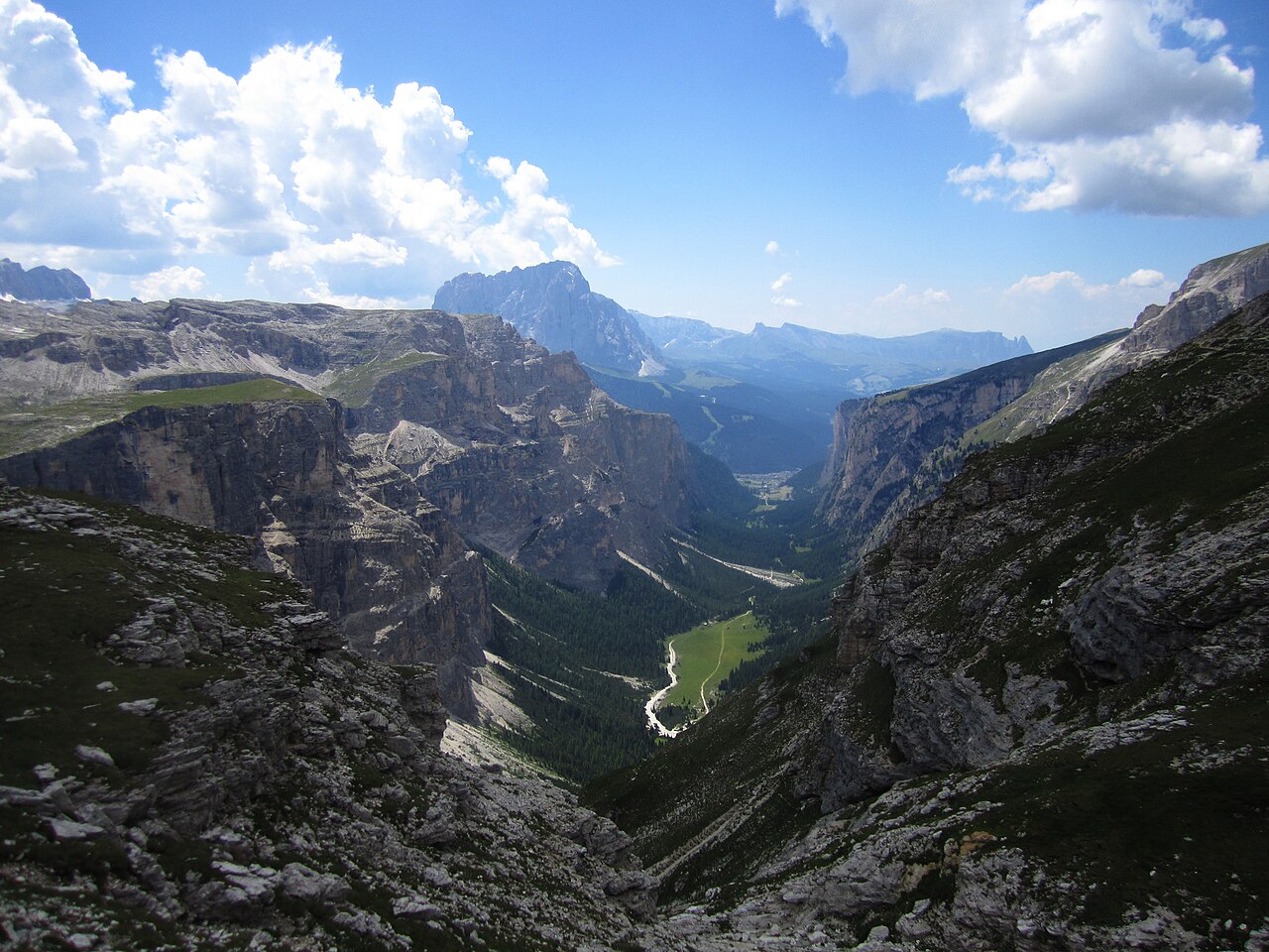

Let the valley be the experience
Vallunga, also called Langental, offers a clear contrast to the high panoramas associated with Val Gardena. You walk within a valley whose walls frame the landscape rather than climbing immediately onto a ridge. Choose it when the lower valley progression itself appeals: chapel, woodland, changing vegetation and meadows beneath the rock. It does not need a high hut at the far end to become a worthwhile outing.
The official walking route uses path14from the valley entrance, passing Saint Sylvester chapel and continuing towards the broader meadow setting. Return by the same planned line. Higher Puez routes are different undertakings. The fact that the valley provides access to them does not make them natural extensions of every valley walk.
Count the connection from Selva
The valley entrance and central Selva are different starting references. Retain both Vallunga and Langental in your notes; they identify the same valley rather than two neighbouring walks to combine. If leaving accommodation on foot, include the connection to the actual entrance and the return. A route measured from the valley start does not describe your complete accommodation-to-accommodation day. This can be a satisfying connected walk, but it should be selected honestly rather than added invisibly beneath a short valley statistic.
If beginning at the entrance, keep that start explicit on the map. Different Vallunga listings describe different activity types and extents, including winter and Nordic-walking variants. Do not combine their smallest distance, easiest label and most ambitious endpoint into a route that no source actually describes. The simple valley out-and-back is enough to organise the day without collecting every variation.
The chapel is a useful reference, not an obligatory turnaround
Saint Sylvester chapel gives an early named landmark and can help a shorter walk feel deliberate. A group wanting a modest outing can select an appropriate turn-back in that portion rather than assume it must reach the full valley endpoint. A group wanting more sustained valley walking can continue according to its researched map. The important agreement is how much of the valley constitutes today's plan.
The landscape changes beyond the initial area, with woodland giving way through the valley's narrower and more open parts. That sequence is the reward for choosing a longer version. It should not be presented as the same brief stroll with one small extra section. Distance and time still accumulate even when the terrain feels less dramatic than an alpine pass.
Three sensible scopes
For a lighter day after a major climb, the first or second can provide a genuine contrast if the ground and conditions suit the group. For somebody whose main aim is a high crossing, the third needs the full independent assessment. A valley route should not be used to make the early part of a much larger day sound reassuringly simple.
Swipe the table horizontally to compare every column.
| Scope | What it gives | What remains separate |
|---|---|---|
| A modest entrance-and-chapel outing | A defined taste of the valley setting | The longer meadow journey |
| The researched valley out-and-back | A fuller sequence beneath the rock walls | The town approach if not already counted |
| A high Puez connection | A separate mountain objective | Any assumption that valley-walk figures describe it |
Easy does not mean every preference is identical
The valley's lower climbing ambition is one advantage, but it does not settle all surface or access requirements. If a specific gradient, width or surface matters, consult the current detailed information for the exact portion you intend. Do not transfer a general family label to every longer continuation or seasonal version. Choose the real line rather than the broad destination name.
For an ordinary mixed group, an agreed out-and-back gives useful control. Turn before the outing becomes more than the party wanted, not only when a distant official endpoint is reached. A partial valley walk can be a positive plan when everyone understands its purpose. It becomes frustrating only when one person's private goal keeps moving the turnaround farther away.
A valley view deserves attention at walking pace
Notice the way the walls appear to move as the near woodland changes. A valley route reveals scale through repeated framing rather than a single summit reveal. Stop at appropriate places and let others pass. Do not move into meadow or vegetation simply to remove the path from a photograph. The authorised walking line already supplies changing compositions without treating the surroundings as unrestricted foreground.
The return also has value because the valley opens in another direction. An out-and-back is not a failure to create a loop. It simplifies the route shape and lets the day remain about observation. A mapped high connection made solely to avoid repetition can transform a restful valley plan into a completely different mountain day.
Use Vallunga as a distinct Val Gardena day
Pair it within a holiday with a separate panoramic objective, such as an appropriately assessed plateau or ridge visit, rather than adding several high routes to the same outing. The contrast is useful: one day from within the valley, another from above it. If staying elsewhere in Val Gardena, map the actual journey to Selva and the entrance instead of assuming the whole valley is one walking start.
Consult current local route and condition information before departure. This guide provides no service timetable and no winter suitability promise. Its enduring recommendation is a clear start, a chosen turnaround and a complete return, with the higher Puez routes kept outside the valley day unless they are the separately researched purpose of the outing.
Questions answered
Is a chapel-and-return walk incomplete?
No. A modest planned portion can be a complete valley experience. Choose the turnaround to match the group rather than a distant landmark by default.
Is a Puez high route the same activity?
No. It changes the terrain, climbing and commitment. Research the complete mountain outing independently.
Sources & scope
Route facts are drawn from the resources below. The comparisons and recommendations are our research-based editorial analysis; this is not a claim of personal trail inspection. Access and conditions must be checked with the responsible land manager before travel.
Editorial standards · Explore the destination guides
Found a detail that needs correcting? Send the guide URL and a supporting source so we can review the exact route version.