
Make the place name precise
Raven Crag is a name encountered in more than one Lake District landscape. This guide concerns the forested hill above Thirlmere’s northern reservoir area, not the climbing crags above Langdale or another same-name feature. Include Thirlmere when researching the route, checking photographs or choosing a map. A search result that shows rock and trees is not enough to establish that it describes the same place.
The reservoir and its surrounding access network are managed by United Utilities, while the wider landscape contains several distinct walks. A route to the upper Raven Crag viewpoint is not a synonym for a circuit around Thirlmere. Start with the precise objective and chosen approach. This gives the day a clear identity before any distance, photograph or recorded track is used to assess it.
A forest ascent is still a climb
The Raven Crag approach moves upward through woodland toward the upper viewpoint. That creates a strong contrast between enclosed trees and the final view along the reservoir. The climb is the route’s principal physical element, even though the forest can make the environment look less exposed than an open fell. Do not infer a nearly level stroll from the presence of conifers or a constructed viewpoint.
Surface can change between access track and narrower woodland walking. A complete route account should be read for those transitions rather than reduced to the most convenient section. The Cumbria Wildlife Trust’s walking material identifies a mixture of road, track and woodland trail in the broader route. That variety is useful context, but its complete start and finish must be matched before borrowing any measurements. A forest destination can have several approach arrangements with different totals.
The view is the destination, not a photo challenge
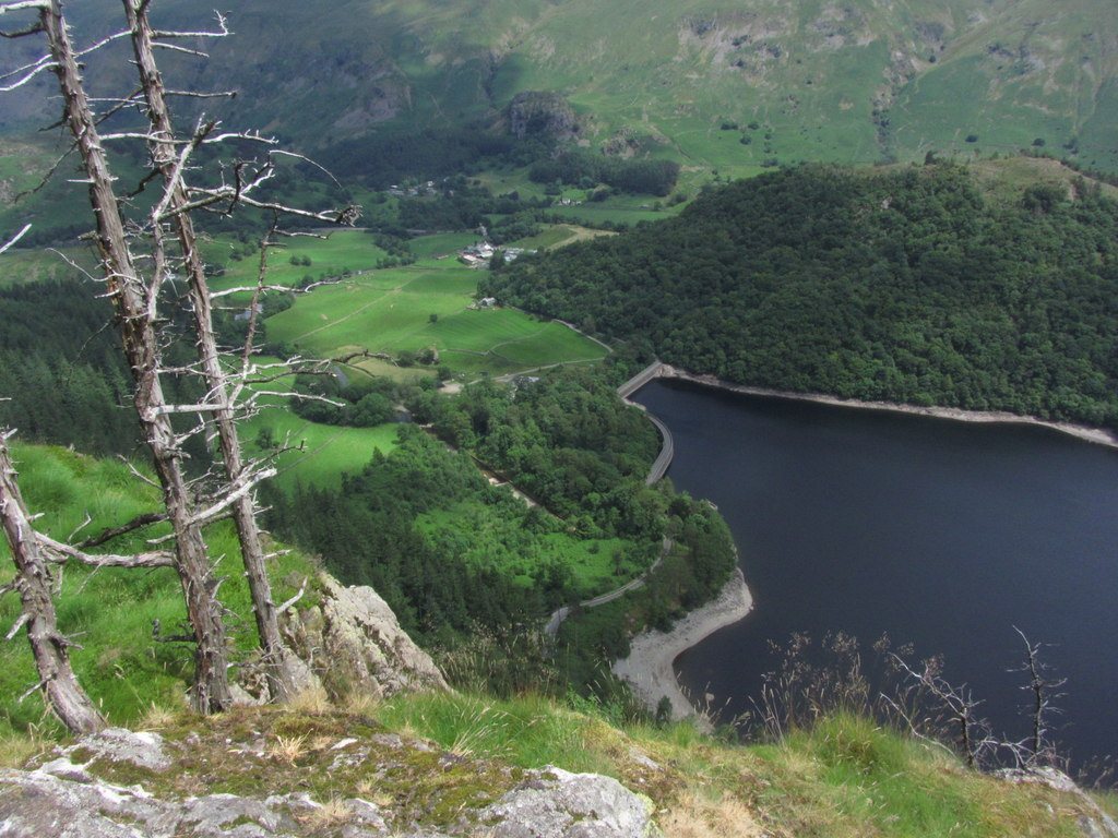
The upper established viewpoint reveals Thirlmere as a long reservoir enclosed by wooded slopes and higher fells. This is a different relationship with the water from a shore path. From above, the shape of the valley and the engineered water body become the main subject. A visitor can appreciate that geography without searching for an informal ledge or leaving the designated viewing area.
The land manager has documented pressure on the landscape associated with inappropriate visitor behaviour. The planning response is simple and specific: choose a day walk on the established access network and use the intended viewpoint. This is not a wild-camping or social-media challenge itinerary. The photograph should represent the actual place and legal walking experience, not encourage a search for a more precarious position because a railing or platform is absent from somebody else’s image.
Return to the start you actually chose
A straightforward viewpoint outing can use a defined return through the forest. The descent then includes the ground that was climbed earlier, so a short steep section remains relevant after the view. If you select a larger circuit through the surrounding access network, understand its complete line and connections rather than assuming any broad forest track will eventually provide an equivalent finish.
Thirlmere access can be affected by land management, storm damage and works. An evergreen article should therefore explain the stable route relationship while directing operational questions to United Utilities. It should not assert that an old closure map proves the route is closed today, or that an old reopening notice proves every surrounding path is open. Choose the current manager’s access information for the actual visit and keep it separate from the enduring description of the climb and viewpoint.
The published woodland circuit has an asymmetric return
Cumbria Wildlife Trust’s published circuit starts at the north-west corner of Thirlmere, at grid reference NY 306189. Its outward shape is road connection, signed forest-boundary ascent, clearing, then the stepped and walkway approach to Raven Crag. The return revisits the clearing before descending on a smaller woodland path and reconnecting with the road. This is a specific circuit, not a general instruction to follow any forest track back downhill.
The Trust gives this version as approximately 5 kilometres with 460 metres of ascent. Its descent is described as short, steep and rubbly in places, so the loop is not a way to exchange every steep section for a gentle forest-road return. Choose it when that asymmetric climb-and-descent shape appeals. The source contains dated access notices; use its stable route structure for comparison and the reservoir manager for current access, without reproducing the old closure as today’s status.
Do not attach a reservoir circuit by habit
The view from Raven Crag can make a circuit of Thirlmere look like an inviting next step. It is nevertheless a different outing with its own distance and route network. A compact hill plan should not retain its short measurement after adding a substantial shore journey. The fact that both experiences feature the same water does not make one a minor extension of the other.
Choose Raven Crag for the forest-to-panorama sequence. Choose a reservoir-side walk when the close relationship with woodland and water is the principal interest. If both are desired, calculate a complete mapped combination and assess it as a larger day. This preserves the useful distinction between looking over the valley and moving through its shore landscape. A clear objective, correct place identity and honest return provide more value than a loosely connected collection of Thirlmere viewpoints.
The reservoir setting gives the viewpoint an additional interpretive purpose. Thirlmere is an engineered water landscape rather than simply a natural lake overlooked by a hill. Looking along it from the established upper viewpoint can make that valley-scale relationship clearer without requiring a full circuit of the shore.
Questions answered
Is Raven Crag a walk around Thirlmere?
No. The hill viewpoint and the reservoir circuit are distinct objectives. Combining them changes the route’s scale and needs a complete plan.
Why must the name include Thirlmere?
Raven Crag is repeated elsewhere. The geographic qualifier helps prevent wrong-route research and incorrect photograph matching.
Can an old access map establish today’s conditions?
No. Operational access should be checked with the land manager for the visit. Old notices provide history, not a permanent live status.
Sources & scope
Route facts are drawn from the resources below. The comparisons and recommendations are our research-based editorial analysis; this is not a claim of personal trail inspection. Access and conditions must be checked with the responsible land manager before travel.
- United Utilities: Thirlmere reservoir
- Cumbria Wildlife Trust: Raven Crag walking landscape
- Keswick tourism: Raven Crag viewpoint context
Editorial standards · Explore the destination guides
Found a detail that needs correcting? Send the guide URL and a supporting source so we can review the exact route version.